Before storm season
Keep current roof imagery on file before major weather events.
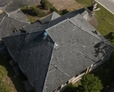
Residential Drone Roof Documentation
Get clear overhead roof imagery for homeowner records, contractor conversations, pre-storm files, roof work planning, and future comparison. Southview Drone Imaging documents visible roof surfaces and roof features with drone imagery and organized digital delivery, without walking on your roof.
Visible photo documentation only. Not a home inspection, roof certification, insurance adjustment, engineering evaluation, appraisal, legal survey, code inspection, or damage assessment.
Quick Answer
Drone roof photos can show visible roof surfaces, ridges, valleys, gutters, vents, flashing, roof penetrations, roof edges, nearby trees, driveway access, and surrounding site context. They are useful for owner records and planning, but they do not diagnose roof condition or replace a licensed roof inspection or certification.
Use Cases
Designed for practical homeowner documentation before visible conditions change.
Keep current roof imagery on file before major weather events.
Document visible roof areas before repairs, replacement, or contractor staging.
Maintain dated roof images without needing someone to climb onto the roof.
Compare visible roof areas before and after storms, maintenance, or exterior projects.
What You Get
Coverage depends on the selected package, safe flight conditions, visibility, property access, and requested add-ons.
Overhead imagery of roof planes, ridges, valleys, and visible shingle areas.
Images of roof edges, gutter lines, and visible drainage features where safely visible.
Documentation of visible vents, flashing, skylights, chimneys, and roof penetrations.
Organized image delivery through a digital gallery or customer portal.
Details
Drone roof photography can capture overhead roof views without roof walking, ladders, or physical roof access.
A dated set of roof photos can be helpful before contractor planning, roof replacement, gutter work, tree trimming, or exterior repairs.
The service provides visible imagery only. It does not certify the roof, determine remaining life, diagnose leaks, or provide engineering or insurance opinions.
Roof imagery is commonly useful before storm season, after routine maintenance, or before visible conditions change.
Related Pages
These pages target more specific timing, project, and documentation needs.
Southview Drone Imaging is FAA Part 107 certified and insured. We create visible photographic documentation only and do not perform inspections, insurance adjusting, engineering evaluations, appraisals, roof certifications, land surveys, code inspections, or damage assessments.
FAQ
No. We provide visible photographic documentation only. We do not perform roof inspections, certifications, engineering evaluations, or damage assessments.
No. The service is non-invasive and uses drone and ground-level imagery.
Visible roof surfaces, edges, gutters, vents, flashing, ridges, valleys, and roof penetrations can be documented when safe flight conditions and visibility allow.
Yes. Many homeowners use the organized gallery or portal to share images with contractors for conversation and planning.
Schedule Your Record
Book a residential photo record for your home and keep organized roof, exterior, property, and optional interior documentation for future reference.