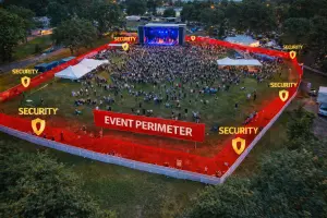
Event Aerial Overwatch & Perimeter Documentation in Central Florida
Site-authorized aerial visibility and organized documentation that support coordination, planning, after-action review, and situational awareness for events, facilities, and defined sites.
Quick Answer
Event aerial documentation provides authorized overhead views of defined event areas, parking flow, access points, crowd movement, and perimeter context. It is a visual coordination tool for event teams and facility staff, not law-enforcement surveillance or private-property monitoring.
Large events and defined sites share a common challenge: site awareness. When vehicles, access points, staging areas, and activities are spread across a wide area, it can be difficult to understand changing conditions from ground level alone. Aerial documentation gives authorized teams a broader operational view.
Drone-based event aerial overwatch and perimeter documentation provide an elevated perspective that complements ground operations. Aerial imagery can provide broad coverage and documented visuals that help organizers, site managers, and authorized stakeholders coordinate decisions, review site conditions, and document what occurred.
At Southview Drone Imaging, we provide professional aerial monitoring services designed to support events, facilities, and temporary or permanent sites that require enhanced visibility. Our approach focuses on coordination, safety, and responsible operation, delivering useful information without unnecessary disruption.
What Is Event Aerial Overwatch & Perimeter Documentation?
Event aerial overwatch and perimeter documentation involve the use of aerial imaging to observe, document, and support oversight of a defined area. This may include vehicle flow, access points, crowd-flow context where authorized, perimeter features, staging areas, and overall site activity.
Drone monitoring does not replace on-the-ground security or management teams. Instead, it supports their work by providing a broader view, helping document developing conditions and support coordinated responses.
Why aerial visibility matters
From ground level, it is easy to miss emerging patterns. Congestion, access-point concerns, bottlenecks, or perimeter changes can develop outside the immediate view of staff. An aerial perspective can document these patterns so authorized teams can decide what action is appropriate.
Aerial monitoring also creates a shared operating picture. Decision-makers, security leads, and event coordinators can reference the same visuals, improving communication and alignment.
Benefits of Drone-Based Aerial Documentation
Aerial overwatch imagery offers distinct advantages over fixed cameras or ground patrols, especially for temporary or large-scale environments.
Wide-area coverage
A single drone flight can cover an area that would otherwise require multiple cameras or patrols. This makes it easier to maintain awareness across parking areas, access roads, crowd zones, and perimeter boundaries.
Rapid repositioning
Unlike fixed cameras, drones can be repositioned quickly to focus on areas of concern. This flexibility is especially valuable during dynamic events where conditions change rapidly.
Improved coordination
Aerial visuals support better coordination between authorized teams. Traffic managers, event staff, site managers, and security personnel can use documented site context to coordinate resources more effectively.
Documented oversight
Recorded aerial footage provides documentation of conditions and actions taken. This can be useful for post-event review, reporting, and continuous improvement planning.
Event Aerial Documentation Applications
Events, whether public, private, or commercial—often involve large numbers of people and complex logistics. Aerial overwatch imagery enhances situational awareness while minimizing intrusion.
Crowd movement and density monitoring
Understanding how crowds move and where they gather is critical for safety. Aerial imagery can reveal congestion points, uneven distribution, and developing bottlenecks that are difficult to detect from the ground.
- Identifying overcrowded areas
- Documenting ingress and egress routes
- Supporting safe crowd flow adjustments
- Reviewing crowd-flow patterns where authorized
Traffic and parking oversight
Traffic congestion and parking challenges are common sources of frustration and risk at events. Drone monitoring provides a real-time overview of vehicle flow, queue buildup, and access routes.
- Monitoring vehicle entry and exit points
- Identifying congestion before it becomes severe
- Supporting traffic control coordination
- Documenting parking utilization
Temporary infrastructure monitoring
Many events rely on temporary infrastructure such as tents, stages, fencing, and barriers. Aerial imagery can help verify placement, document visible gaps, and confirm that layouts match planning documents.
Perimeter Documentation for Facilities & Sites
Beyond events, drone-based monitoring is valuable for facilities and sites that require enhanced perimeter awareness. This includes industrial properties, construction sites, storage yards, and remote facilities.
Boundary visibility
Aerial monitoring provides a clear view of perimeter boundaries, fencing, gates, and buffer zones. This makes it easier to document visible fencing, gates, damage, and access-point concerns for review by the site team.
Access-point documentation
Aerial imagery can document unexpected visible activity near defined access areas. Any response, investigation, enforcement, or person-identification decision should be handled by the authorized site team or appropriate authority.
Remote or large properties
For large or remote sites, ground patrols can be time-consuming and inefficient. Aerial monitoring provides rapid coverage and helps focus on areas that truly need attention.
Supporting Security and Management Teams
Aerial overwatch imagery is most effective when integrated into existing operations. The goal is to support, not replace—on-site teams by providing additional information and context.
Real-time decision support
During active operations, aerial visuals can help leadership make informed decisions quickly. Whether adjusting traffic flow, reviewing access points, or documenting an incident area, having clear site context can improve coordination.
Post-event review and improvement
Recorded footage allows teams to review what worked and what didn’t. This supports continuous improvement in event planning, site layout, and site-management procedures.
Deliverables That Provide Clarity
Aerial overwatch and documentation data must be clear, organized, and usable. Southview Drone Imaging focuses on delivering visuals that integrate easily into reporting and review workflows.
- High-resolution aerial photos
- Recorded aerial video segments
- Time-stamped imagery for documentation
- Optional annotations highlighting key observations
- Organized files by date and area
Clear organization and labeling
Files can be structured by event phase, location, or time window, making it easy to review specific moments or areas without confusion.
Privacy, Safety, and Responsible Operation
Aerial monitoring must be conducted responsibly. All operations are performed in accordance with FAA Part 107 regulations, applicable authorization requirements, privacy considerations, and site-specific safety planning.
Operating in public and sensitive environments
Event and perimeter documentation may occur near people or neighboring property. Flights are planned to minimize risk, avoid unnecessary capture, and respect applicable privacy, consent, and site-control requirements.
Coordination with stakeholders
Successful monitoring depends on coordination with event organizers, site managers, and site-authorized teams. Clear communication ensures the aerial operation supports overall objectives.
Use Cases Beyond Events
While events are a common application, perimeter documentation also supports:
- Construction site documentation
- Industrial facility documentation
- Temporary installations or staging areas
- Remote property visual documentation
- Pre- and post-operation documentation
Adapting to changing needs
Drone monitoring services can be tailored to the scope and duration of a project—from a single-day event to ongoing site oversight.
Why Choose Southview Drone Imaging
Event aerial overwatch and perimeter documentation require professionalism, discretion, and clear objectives. Southview Drone Imaging focuses on providing aerial visibility that supports safety, coordination, and informed decision-making.
We understand that monitoring operations may be reviewed by multiple stakeholders and must be conducted responsibly, legally, and with purpose.
Enhancing Awareness When It Matters Most
Better visibility supports better coordination. Whether managing a large event or documenting a defined site area, aerial imagery provides useful context for authorized review and planning.
If you’re planning an event or managing a site that would benefit from enhanced aerial awareness, Southview Drone Imaging is ready to help with professional, responsible monitoring services.
Next steps
Tell us what you need and we’ll recommend the best deliverables and turnaround.