Before exterior renovation
Document current layout before painting, siding, windows, patios, additions, or other exterior improvements.
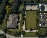
Before Renovations and Exterior Projects
Create a dated visual record before exterior renovations, landscaping, drainage work, pool projects, tree work, additions, roof work, or other improvements change the property. Southview Drone Imaging provides aerial and ground-level imagery that helps homeowners plan, document, and compare visible conditions before and after projects.
Visible photo documentation only. Not a home inspection, roof certification, insurance adjustment, engineering evaluation, appraisal, legal survey, code inspection, or damage assessment.
Quick Answer
Aerial documentation shows the relationship between the home, driveway, trees, drainage areas, pool areas, patios, detached structures, fences, and yard layout. It helps homeowners preserve a visual record before work begins and makes future before/after comparisons easier.
Use Cases
Designed for practical homeowner documentation before visible conditions change.
Document current layout before painting, siding, windows, patios, additions, or other exterior improvements.
Record trees, slopes, drainage areas, beds, hardscapes, and yard layout before changes.
Capture pool areas, patios, decks, walkways, fences, and surrounding site context.
Use a follow-up visit to document completed work and maintain a clean owner archive.
What You Get
Coverage depends on the selected package, safe flight conditions, visibility, property access, and requested add-ons.
Aerial context of the home, yard, driveway, pool areas, detached structures, and landscaping.
Ground-level and drone views of visible exterior features relevant to the project.
Access points, drainage areas, trees, fences, and outdoor features where visible.
A second visit after the project can create before/after comparison records.
Details
Aerial imagery makes it easier to understand how exterior features relate across the full site.
A dated record before construction or landscaping activity helps preserve the current visual baseline.
Images can help homeowners talk with contractors about access, site features, drainage, tree coverage, and exterior layout.
This service does not provide design, engineering, surveying, permitting, code, inspection, or construction opinions.
Related Pages
These pages target more specific timing, project, and documentation needs.
Southview Drone Imaging is FAA Part 107 certified and insured. We create visible photographic documentation only and do not perform inspections, insurance adjusting, engineering evaluations, appraisals, roof certifications, land surveys, code inspections, or damage assessments.
FAQ
Exterior renovations, roof work, additions, patios, pools, landscaping, drainage work, tree work, fencing, and driveway projects often benefit from a dated visual record.
Yes. A follow-up comparison visit can be added after a project, storm, or repair.
No. It is visual documentation only and does not replace a survey, site plan, engineering drawing, permit document, or code inspection.
Yes. A contractor or roofer sharing package can be added when you want organized sharing access.
Schedule Your Record
Book a residential photo record for your home and keep organized roof, exterior, property, and optional interior documentation for future reference.