Agriculture & Land Monitoring by Drone in Central Florida
From crop health checks to acreage documentation, drone-based monitoring delivers fast, repeatable, high-quality visuals that help landowners, growers, and property managers make better decisions with less time in the field.
Quick Answer
Agriculture and land drone monitoring provides current aerial imagery of farms, groves, acreage, drainage areas, and rural parcels. It is useful for visual records, change tracking, storm follow-up, and planning discussions, but it is not a crop diagnosis, legal survey, or engineering deliverable.
Agriculture and land management have always depended on good information. The challenge is that fields, groves, ranch land, timber stands, and rural properties are large, dynamic, and often hard to evaluate from the ground. Walking a property can take hours, and even then you only see what’s visible from the paths you take. Satellite imagery can be useful, but it may be outdated, cloud-obscured, or not detailed enough when you need to spot small issues early.
That’s where drone-based agriculture & land monitoring comes in. Drones provide a high-resolution “overview” that’s current, repeatable, and easy to share. You can inspect large acreage quickly, document conditions before and after storms, keep records of changes over time, and capture the kind of visual detail that helps you act before small problems become expensive ones.
At Southview Drone Imaging, we provide professional aerial monitoring services tailored to landowners, growers, farm managers, contractors, and anyone responsible for maintaining or evaluating property. Our goal is simple: deliver clear visuals and organized deliverables that help you understand your land, track change, and make decisions with confidence.
What Is Agriculture & Land Monitoring?
Agriculture & land monitoring is the process of observing and documenting land conditions over time. Depending on the property and your goals, that monitoring might focus on crop vigor, irrigation performance, drainage and erosion, timber health, visible property context, storm impacts, pasture conditions, or general property oversight. The common thread is repeatability: you want reliable visuals you can compare month-to-month or season-to-season.
Drone-based monitoring adds speed and perspective. You can cover more ground in less time, see patterns that are hard to detect at eye level, and create an clear visual record you can share with partners, consultants, insurers, buyers, or contractors.
Why drone monitoring is different
A drone flight captures a consistent view of your land from above. Instead of relying on memory or scattered notes, you get a set of images and/or video that show the property in context. This is especially valuable when you need to communicate with people who aren’t on-site—owners who live out of town, buyers evaluating a property remotely, or contractors planning work.
Drone monitoring is also repeatable. When flights follow a consistent plan, you can compare conditions across time—before and after major rain events, at key growth stages, or across the same time of year. That repeatability turns visuals into a practical management tool.
Common Use Cases
Every property is different, but most agriculture and land monitoring requests fall into a handful of high-value categories. Below are some of the most common ways drone imagery helps landowners and operators.
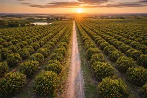
Crop and grove oversight
Aerial visuals can reveal patterns that are hard to notice from the ground: thin stands, irregular growth, problem rows, localized flooding, storm damage, and areas that may be under stress. Even standard RGB imagery (high-resolution photos and video) can be surprisingly informative when it’s captured at the right altitude, with consistent coverage and good lighting.
For citrus groves, row crops, nurseries, and specialty farms, drone monitoring can help you:
- Identify areas of uneven growth or poor canopy density
- Spot storm impact or wind damage quickly
- Document field condition at key times (pre-harvest, post-harvest, seasonal change)
- Create shareable visuals for partners, consultants, and remote owners
Irrigation checks and water management
Water is one of the most expensive and most important inputs in agriculture and land management. Drone imagery can help verify that irrigation coverage looks consistent across a property, identify pooling areas, and document drainage patterns after rain. In flat areas like much of Central Florida, subtle landform and drainage differences can have a big impact on where water sits and how long it stays.
Aerial monitoring is especially helpful after heavy rains, when you need to see:
- Where standing water is accumulating
- How quickly different parts of the property dry out
- Whether ditches, canals, or culverts appear blocked
- Where erosion or washout is beginning
Pasture, ranch, and land-use documentation
Pasture and ranch properties are often large and irregular. Drone monitoring provides a quick way to document fencing lines, gate access, forage condition, wet spots, and general land use. It’s also useful for owners who need a visual record for planning improvements or coordinating work with contractors.
For rural property owners, drone monitoring can support:
- Fence-line overview and access planning
- Identifying low areas and persistent wet ground
- Documenting land condition for lease agreements
- Visual records for lenders, partners, or family ownership groups
Timber and wooded property monitoring
Timberland and wooded acreage can be difficult to evaluate from the ground, especially when undergrowth is thick or access is limited. Drone imagery can document storm damage, access roads, clearing boundaries, and general canopy condition. It’s also useful for tracking the progress of land clearing, thinning operations, and new road or pad construction.
After storms, aerial monitoring can help confirm:
- Where trees are down and whether access routes are blocked
- Extent of canopy damage and blowdown patterns
- Whether debris is concentrated in certain areas
- Changes to drainage caused by fallen timber or washouts
Visible property context and property planning
If you’re buying, selling, or improving rural property, clear visuals matter. Drone photos can show tree lines, visible fence lines, cleared areas, and access points in a single view. This is extremely useful for planning projects like fencing, driveway construction, land clearing, pond maintenance, or site prep.
Aerial imagery can also support better conversations with contractors: instead of trying to describe a location over the phone, you can point to a specific image and share exactly what you mean.
Seasonal Monitoring: Turning Photos Into a Management Tool
One-time aerial coverage is valuable, but the real power of monitoring is consistency over time. A seasonal monitoring plan creates a visual timeline of your property. You can compare images from the same altitude and perspective at different points in the year and quickly understand what changed.
Examples of useful monitoring schedules include:
- Monthly flights during active growth or high-change seasons
- Quarterly flights for general land management and documentation
- Pre- and post-storm flights to support claim discussions and repairs
- Before and after documentation for clearing, grading, and drainage work
With consistent capture, your aerial imagery becomes more than “nice photos.” It becomes a decision tool that helps validate improvements, confirm results, and document trends.
Before-and-after documentation
Land improvements often happen in stages: clearing, grading, drainage, access roads, planting, replanting, or irrigation upgrades. Drone imagery is a clean way to document each phase. This helps with contractor accountability, planning next steps, and keeping clear records for ownership groups or long-term managers.
If you ever need to prove timelines or show what was done (and when), having organized aerial documentation is invaluable.
Deliverables That Are Easy to Use
Good monitoring isn’t just about flying a drone. It’s about delivering usable results. Our goal is to provide clear, organized deliverables you can review quickly and share easily.
Depending on your needs, deliverables may include:
- High-resolution aerial photos (ideal for documentation and detailed review)
- 4K aerial video (great for sharing progress and property overviews)
- Time-stamped visuals for record-keeping and comparison
- Annotated images (optional) to highlight specific areas of interest
Organized image sets
For monitoring work, organization matters. We can provide image sets grouped by area or flight date, making it easier to compare and track changes. If you want to monitor multiple parcels, we can keep each property separated and labeled for clarity.
Who Benefits From Agriculture & Land Monitoring?
Aerial monitoring is useful for more than commercial farms. If you manage land, own acreage, or need to document conditions, drone imagery can pay for itself quickly in time saved and better decisions.
Landowners and rural property managers
If you own acreage and don’t live on it full-time, drone monitoring provides a reliable overview. You can check on access, spot access concerns, document storm impacts, and keep a consistent record of the property’s condition. It’s also helpful for coordinating maintenance work with contractors or caretakers.
Growers and farm operators
Drone monitoring helps you see patterns across fields and blocks. Even without specialized sensors, high-resolution visuals can show uneven canopy development, storm damage, irrigation issues, and areas that need attention.
Land planning and project coordination
Aerial imagery is one of the best tools for planning land improvements and coordinating field work. It shows access roads, clearings, water features, and the overall character of a property in a way that ground photos can’t. It provides clarity for owners, contractors, and project teams who need a shared visual reference.
Insurance and storm documentation
After major weather events, landowners often need clear documentation of damage. Drone imagery can capture wide context and detailed close-ups—useful for insurance conversations and for coordinating cleanup and repairs.
Safety, Compliance, and Professional Operation
Professional drone work requires more than a capable aircraft. It requires planning, safety awareness, and compliance with FAA regulations. All monitoring operations are conducted in accordance with FAA Part 107 rules and are planned to reduce risk and avoid unnecessary disruption.
If your property is near airports, controlled airspace, or other sensitive areas, proper planning becomes even more important. We handle flight planning and operational best practices so you get the results without the headaches.
Minimal disruption to your operation
For active agricultural operations, timing matters. Flights can be planned to avoid peak equipment movement, minimize disruption to workers, and take advantage of the best lighting for clean imagery. The goal is to be efficient, respectful of the property, and focused on deliverables that help you.
How to Get the Most Value From Monitoring
If you’re considering drone monitoring for the first time, a little planning goes a long way. The most valuable projects start with a clear purpose. Are you documenting for record-keeping? Looking for issues after storms? Tracking changes from land work? Preparing to sell? Each goal suggests a slightly different capture plan and deliverable package.
Start with the questions you want answered
Monitoring becomes far more useful when you know what you’re looking for. A few examples:
- “Where is water collecting after heavy rain?”
- “How is the land changing after clearing and grading?”
- “Do we have visual documentation of the property condition this season?”
- “Can we show buyers the access points and layout clearly?”
When you define the purpose, we can tailor the flight plan and deliverables to match.
Repeat flights for true monitoring
If your goal is to track change, consider a simple schedule: quarterly, monthly, or pre/post events. Even a small set of repeat flights can provide huge value, especially if you’re managing land improvements, documenting storm seasons, or coordinating ongoing work.
Why Choose Southview Drone Imaging
You don’t just need a drone—you need results that are reliable, clear, and useful. Southview Drone Imaging approaches agriculture and land monitoring with a professional mindset: plan the flight, capture consistent coverage, and deliver organized files you can review and share.
Whether you manage a grove, run a farm, own rural acreage, or need to document land condition for a project, we help you see the full picture from above—quickly and safely.
Ready to Monitor Your Land?
If you’d like to discuss agriculture or land monitoring for your property, we’ll help you choose a practical approach— from a one-time overview to a simple seasonal monitoring plan. The result is straightforward: better visibility, better documentation, and better decisions.
Visit Southview Drone Imaging to learn more about our services, or reach out to schedule a flight and start building a clear visual record of your land.
Next steps
Tell us what you need and we’ll recommend the best deliverables and turnaround.