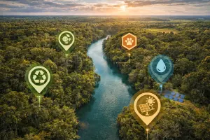
Environmental & Conservation Aerial Imaging in Central Florida
High-resolution aerial imagery that supports environmental stewardship, land conservation, and data-driven decision-making—captured safely, efficiently, and with minimal site impact.
Quick Answer
Environmental and conservation drone imaging captures repeatable aerial visuals of wetlands, waterways, conservation areas, drainage patterns, and land-change conditions. It is useful for planning support and visual records, but it does not replace environmental delineations, permitting work, or professional field verification.
Environmental and conservation work depends on understanding what is happening on the land. Whether the goal is habitat protection, restoration planning, land-use monitoring, or regulatory documentation, reliable visuals are essential. Many environmentally sensitive areas are large, difficult to access, or fragile, making traditional ground review time-consuming and sometimes disruptive.
Drone-based environmental and conservation imaging provides a modern solution. Aerial imagery offers a broad perspective while still capturing fine detail, allowing land managers, conservation groups, researchers, and agencies to observe patterns, document change, and communicate findings clearly.
At Southview Drone Imaging, we provide professional environmental and conservation imaging services designed to support responsible land management. Our approach emphasizes accuracy, repeatability, and respect for sensitive environments, delivering visuals that inform decisions without unnecessary disturbance.
What Is Environmental & Conservation Imaging?
Environmental and conservation imaging involves capturing aerial visuals to document natural landscapes, ecosystems, and land-use conditions. These images help establish baselines, monitor change over time, and support planning, reporting, and public communication.
Drone imaging is particularly effective for conservation work because it allows large areas to be documented quickly while limiting human impact on the ground. This makes it ideal for wetlands, preserves, waterways, wildlife corridors, and undeveloped land.
Why aerial perspective matters
Environmental processes often occur at a scale that is difficult to grasp from the ground. Drainage patterns, vegetation transitions, erosion pathways, and habitat fragmentation are easier to understand when viewed from above. Aerial imagery reveals relationships and trends that inform better conservation strategies.
Just as important, aerial visuals provide a shared reference point, helping scientists, land managers, regulators, and the public see the same conditions and changes.
Benefits of Drone Imaging for Environmental Work
Conservation and environmental monitoring present unique challenges. Drone-based imaging offers advantages that traditional ground review and ground photography often cannot match.
Minimal environmental disturbance
Sensitive habitats can be damaged by foot traffic or heavy equipment. Drone imaging reduces ground disturbance by capturing data from above, helping protect vegetation, soils, and wildlife while still providing comprehensive coverage.
Efficient coverage of large areas
Many conservation sites span hundreds or thousands of acres. Drone flights can document large areas quickly, making it practical to monitor entire sites rather than isolated sample locations.
Repeatable monitoring over time
Environmental change often happens gradually. Repeatable aerial imaging allows sites to be documented consistently over months or years, supporting long-term monitoring and trend analysis.
Clear visuals for communication and reporting
Environmental projects often involve multiple stakeholders. High-quality aerial imagery helps communicate conditions and progress clearly, whether for internal planning, grant reporting, regulatory-review support or public outreach.
Habitat & Land Cover Documentation
Understanding existing land cover is a foundational step in conservation planning. Drone imagery provides detailed visuals of vegetation types, open areas, water features, and transition zones. This information supports habitat documentation, restoration planning, and impact-review support.
Baseline condition documentation
Baseline imagery captures the condition of a site at a specific point in time. This is critical for evaluating future change and measuring the effectiveness of conservation or restoration efforts.
- Vegetation density and distribution
- Visible wetland edges and surface water extent
- Open land versus wooded areas
- Existing disturbances or access paths
Supporting restoration planning
For restoration projects, aerial imagery helps identify priority areas, plan access routes, and visualize how different habitats connect. It also provides a clear record for documenting work before implementation begins.
Wetlands, Waterways, and Drainage Monitoring
Wetlands and water systems are dynamic environments influenced by rainfall, seasonal changes, and human activity. Drone imaging provides an efficient way to document surface water extent, flow paths, and surrounding vegetation without disturbing sensitive areas.
Surface water documentation
Aerial imagery can capture:
- Water coverage after rain events
- Changes in ponding or inundation areas
- Shoreline and wetland edge conditions
- Drainage patterns across the landscape
These visuals are useful for environmental review support, land management decisions, and consultant or agency review documentation.
Seasonal variability
Many water-related features change dramatically throughout the year. Repeat flights during wet and dry seasons provide a clearer understanding of how a site behaves over time.
Erosion and Land Change Monitoring
Erosion and land disturbance can have significant environmental impacts, especially near waterways and sensitive habitats. Drone imaging helps document visible erosion, sediment movement, and land changes across large areas.
Identifying erosion patterns
From above, erosion patterns are often easier to identify. Drone imagery can highlight:
- Exposed soil and sediment movement
- Channel formation and runoff paths
- Changes caused by storms or land use
- Areas needing stabilization or restoration
Before-and-after comparisons
Comparing imagery captured before and after major rain events or land work helps quantify change and supports informed management decisions.
Conservation Land Management & Oversight
Conservation lands often require ongoing oversight to ensure they are being managed as intended. Drone imagery provides a practical way to document access conditions, access concerns, and overall land condition.
Access and visible perimeter context
Aerial imagery can show visible fence lines, access roads, buffer areas, and property context, access roads, and buffer zones. This helps land managers identify encroachments, plan signage, and coordinate maintenance activities.
Monitoring human impact
Drone imaging can reveal visible signs of human activity such as informal trails, vehicle tracks, dumping, or clearing. Early detection supports timely response and mitigation.
Environmental Projects & Reporting
Many conservation and environmental projects require documentation for grants, permits, or public transparency. High-quality aerial imagery strengthens reports by providing clear, visual records of conditions and progress.
Grant and stakeholder reporting
Visual documentation helps demonstrate responsible use of funds and measurable progress toward project goals. Aerial imagery can clearly show changes that are difficult to convey through text alone.
Public outreach and education
Conservation efforts often depend on public understanding and support. Aerial imagery helps tell the story of a landscape—showing why an area matters and how it is being protected.
Deliverables Designed for Real-World Use
Environmental imaging is most valuable when deliverables are clear and organized. Southview Drone Imaging focuses on providing visuals that integrate smoothly into planning, reporting, and archiving workflows.
- High-resolution aerial photos
- Wide-area overview imagery
- Time-stamped image sets for comparison
- Optional annotations highlighting key features
- Before-and-after image groupings
Consistent organization
Files can be organized by date, area, or project phase, making long-term monitoring and historical comparison straightforward.
Safety, Coordination, and Responsible Operation
All environmental imaging flights are conducted in accordance with FAA Part 107 regulations and standard safety practices. Special attention is given to site sensitivity, wildlife considerations, and minimizing disturbance.
Working in sensitive environments
Conservation sites often require careful planning. Flights are designed to avoid unnecessary impact on wildlife and habitats while still capturing the required documentation.
Why Choose Southview Drone Imaging
Environmental and conservation imaging requires more than technical skill—it requires respect for the land and an understanding of why the documentation matters. Southview Drone Imaging approaches every project with a focus on accuracy, repeatability, and stewardship.
Whether you manage conservation land, oversee restoration projects, or need environmental documentation for planning or reporting, we tailor our imaging approach to your goals.
Supporting Conservation Through Clear Visibility
Better decisions start with better information. Environmental and conservation imaging provides the visibility needed to protect landscapes, track change, and demonstrate responsible land management.
If you’re ready to document, monitor, or better understand your land, Southview Drone Imaging is ready to help, providing professional aerial imagery that supports conservation today and into the future.
Next steps
Tell us what you need and we’ll recommend the best deliverables and turnaround.