Construction & Industrial Aerial Imaging in Central Florida
Modern construction and infrastructure projects benefit from repeatable, well-organized, and safety-conscious visual documentation. Drone-based inspection-support imagery delivers usable project records faster, safer, and more cost-effectively than many traditional access methods.
Quick Answer
Construction and industrial drone imaging provides repeatable aerial photos, site overviews, and progress records for project teams. It helps owners, contractors, and stakeholders understand site activity without replacing surveys, engineering review, or formal project controls.
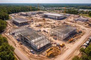
Construction and asset documentation is a practical way to improve visibility, control costs, and maintain records across buildings, infrastructure, and industrial facilities. Traditional access often requires scaffolding, lifts, rope access, traffic closures, or personnel exposure to elevated or hazardous environments. Today, drones make it easier to capture visual documentation from hard-to-reach angles.
At Southview Drone Imaging, we provide professional construction and asset documentation services designed to support informed decision-making throughout the lifecycle of a project or structure — from pre-construction planning through ongoing maintenance review. Our documentation workflows emphasize consistency, organization, and efficient capture while minimizing disruption to active sites.
What Is Construction & Asset Documentation?
Construction and asset documentation uses structured imagery to record visible site conditions, capture progress, and support review by the appropriate project team. Assets can include buildings, bridges, roofs, towers, facades, utilities, and industrial equipment.
Drone-based inspection-support imagery can supplement traditional visual documentation by capturing high-resolution aerial imagery and video from vantage points that are difficult, dangerous, or time-consuming to reach on foot. This approach gives stakeholders a clearer visual record without unnecessary exposure to access-related risk.
Why Drone Documentation Supports Construction
The construction industry operates under tight schedules, strict safety requirements, and increasing pressure to control costs. Drone inspection-support imagery helps address all three challenges. By collecting detailed visual imagery quickly and consistently, drones enable teams to make informed decisions earlier and with greater confidence.
Improved Safety
One of the most significant advantages of drone inspection-support imagery is improved safety. Visual review of roofs, facades, towers, and elevated structures often requires workers to operate at height using lifts or scaffolding. Drones eliminate or drastically reduce these risks by keeping personnel safely on the ground while still capturing detailed visuals.
Faster Data Collection
Traditional visual review workflows can take days or weeks to schedule and complete. Drone documentation can often be captured in a single site visit, allowing project teams to receive imagery quickly and keep projects moving forward without delay.
Cost Efficiency
By reducing labor hours, equipment rentals, and site disruptions, drone inspection-support imagery offers a cost-effective alternative to many conventional access methods. The ability to capture comprehensive documentation in one operation can reduce access-related costs.
Applications in Construction Projects
Aerial documentation is valuable across every phase of a construction project. Whether used during planning, active construction, or post-completion review, aerial imagery provides clarity and accountability.
Pre-Construction Baseline Records
Before construction begins, aerial imagery can document existing conditions, surrounding structures, and site constraints. This baseline documentation is invaluable for planning, risk mitigation, and resolving future disputes.
Progress Monitoring
During active construction, drones provide visual progress updates that can be shared with stakeholders, investors, and remote teams. Regular aerial documentation helps teams compare timelines, review visible delays, and understand whether work appears aligned with the project plan.
Quality Review Support
High-resolution imagery allows project managers and inspectors to review visible workmanship details, material placement, and visible installation details. Visible concerns can be documented early, supporting qualified review before rework or corrections become more costly.
Asset Documentation Beyond Construction
Asset documentation does not end when construction is complete. Long-term asset management depends on regular visual records to document visible wear, damage, or environmental effects before they become critical failures.
Roof & Building Envelope Documentation
Roofs, facades, and exterior building components are particularly well suited to drone documentation. Aerial imagery can show damaged membranes, missing materials, drainage issues, and signs of water intrusion that may not be visible from the ground.
Infrastructure & Civil Assets
Bridges, towers, water structures, and transportation infrastructure can benefit from inspection-support imagery that provides close-up visual context for joints, surfaces, and structure-related elements without traffic closures or specialized access equipment in some cases.
Industrial & Utility Assets
Industrial facilities and utility assets often involve complex layouts and hazardous environments. Drone inspection-support imagery allows operators to visually review stacks, tanks, piping, and equipment safely while maintaining operational continuity.
Visual Records You Can Use
The value of aerial documentation lies not only in the images captured but in the consistency and organization of the files. Our documentation workflows focus on consistent capture methods, clear labeling, and structured deliverables that support review by qualified engineers, contractors, owners, project teams, and asset managers.
Deliverables may include high-resolution photos, annotated images, inspection-support videos, and time-stamped documentation suitable for reports, maintenance records, or compliance submissions.
FAA Operations & Professional Scope Limits
All drone documentation flights are conducted in accordance with FAA Part 107 regulations. Professional flight planning, risk assessment, and operational discipline help ensure flights are performed legally and responsibly.
Documentation-focused imaging is especially important for government agencies, municipalities, and regulated industries where documentation and traceability are critical.
Why Choose Southview Drone Imaging
Construction and asset documentation requires more than just flying a drone. It demands an understanding of construction practices, documentation objectives, and stakeholder needs. Southview Drone Imaging brings a methodical, professional approach to every documentation assignment.
We focus on delivering clear, usable visual records, not just scattered images — so clients can make informed decisions backed by organized visual information.
Supporting Smarter Decisions
Drone-based construction and asset documentation gives project teams visual context that were previously difficult or expensive to obtain. By improving safety, reducing costs, and increasing visibility, aerial documentation supports smarter decisions throughout the life of a structure.
Whether documenting construction progress, inspecting critical infrastructure, or supporting long-term asset review, professional drone inspection-support imagery provides clarity when it matters most.
Next steps
Tell us what you need and we’ll recommend the best deliverables and turnaround.