Inventory & Material Tracking by Drone in Central Florida
Clear, repeatable aerial visibility that helps organizations track materials, manage assets, and maintain situational awareness across large or complex sites.
Quick Answer
Aerial inventory and material tracking provides overhead visual records of laydown yards, staging areas, equipment, stockpiles, and site logistics. It supports planning and comparison work, but any volume or quantity references should be treated as non-certified unless coordinated with the appropriate licensed professional.
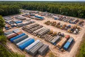
Inventory and material management become increasingly challenging as sites grow larger, inventories expand, and operations move faster. Construction yards, industrial facilities, distribution areas, and storage sites often span wide areas where materials are staged, moved, and consumed continuously. From the ground, it can be difficult to know exactly what is on-site, where it is located, and how conditions are changing over time.
Drone-based inventory and material tracking provides a practical solution by offering a comprehensive aerial view of stockpiles, storage areas, and site layout. Instead of relying solely on manual counts, spreadsheets, or outdated maps, organizations gain current visual documentation that supports better planning, coordination, and accountability.
At Southview Drone Imaging, we provide professional aerial inventory and material tracking services designed to support real-world operations. Our focus is on delivering clear, organized visuals that help teams understand what they have, where it is, and how it is changing—without disrupting ongoing work.
What Is Inventory & Material Tracking?
Inventory and material tracking involves documenting the presence, quantity, and location of materials or assets within a defined area. This may include construction materials, aggregates, equipment, containers, pallets, or staged components awaiting installation or shipment.
Drone-based tracking emphasizes visibility and context. Rather than focusing only on numbers, aerial imagery shows how materials are arranged, how space is being used, and whether staging aligns with plans. This broader perspective helps identify inefficiencies, shortages, or potential issues early.
Why aerial visibility matters
Ground-level tracking often relies on partial views and assumptions. Aerial imagery provides a complete picture of the site, revealing patterns that are difficult to see from eye level— such as uneven stockpile distribution, congestion in storage areas, or underutilized space.
When teams share the same aerial reference, communication improves and decisions become more data-driven rather than reactive.
Benefits of Drone-Based Inventory Tracking
Inventory and material tracking with drones offers advantages across many industries, especially where materials are stored outdoors or spread across large properties.
Wide-area coverage
A single flight can document large storage yards, laydown areas, or multiple staging zones in minutes. This efficiency makes it practical to capture regular updates without pulling personnel away from their primary responsibilities.
Reduced manual effort
Manual counts and ground inspections can be time-consuming and prone to error. Aerial documentation reduces the need for frequent site walks while still providing reliable visual information.
Improved accuracy and consistency
Consistent flight paths and capture methods create repeatable documentation. Over time, this consistency makes it easier to compare conditions, verify deliveries, and confirm material usage.
Better coordination across teams
When inventory information is visual and shareable, coordination improves. Project managers, logistics teams, vendors, and stakeholders can reference the same imagery, reducing confusion and miscommunication.
Construction & Industrial Applications
Construction and industrial sites are among the most common environments for aerial inventory tracking. Materials are often staged outdoors, moved frequently, and consumed at different rates across the site.
Construction laydown yards
Drone imagery provides a clear overview of construction laydown areas—showing where materials are staged, how much space is being used, and whether staging aligns with workflow plans.
- Tracking deliveries and material placement
- Identifying congestion or access issues
- Supporting just-in-time delivery planning
- Documenting material availability for scheduling
Industrial storage and stockpiles
For industrial operations, aerial imagery helps document bulk materials, equipment storage, and outdoor inventory. This is especially useful for materials stored in piles, rows, or designated zones across large properties.
Equipment and asset staging
Heavy equipment and temporary assets are often moved between projects or areas. Aerial overviews help confirm equipment location, staging condition, and availability without requiring physical inspections.
Tracking Change Over Time
Inventory tracking is most valuable when it shows change. Repeat aerial documentation creates a visual timeline of how materials are delivered, moved, and consumed.
Baseline documentation
A baseline flight establishes a reference point for inventory levels and site layout. This is especially useful at the start of a project, after a major delivery, or during operational transitions.
Routine updates
Periodic flights—weekly, biweekly, or monthly—provide ongoing insight into inventory movement. These updates help identify discrepancies early and support proactive planning.
Before-and-after comparisons
Comparing imagery before and after key milestones highlights material usage and progress. This can support internal reporting, vendor accountability, and schedule verification.
Supporting Logistics & Planning
Inventory visibility directly impacts logistics and scheduling. When teams know what is available and where it is located, planning becomes more accurate and efficient.
Delivery verification
Aerial imagery can help verify that deliveries arrived as expected and were staged in the correct locations. This visual confirmation reduces disputes and supports clear record-keeping.
Space utilization
Storage space is often limited. Aerial overviews reveal underused areas, overcrowded zones, and opportunities to reorganize staging for better flow and access.
Workflow optimization
By showing how materials are arranged relative to work areas, drone imagery helps teams identify inefficiencies and improve site layout to reduce handling time and congestion.
Use Cases Across Industries
Inventory and material tracking with drones is valuable across many sectors, including:
- Construction and development projects
- Industrial manufacturing and processing facilities
- Aggregate and materials yards
- Ports, terminals, and logistics hubs
- Municipal storage and public works facilities
Temporary and remote sites
For temporary or remote sites, aerial tracking provides oversight without requiring frequent on-site visits. This is especially useful when management teams are off-site or overseeing multiple locations.
Deliverables That Support Operations
Effective inventory tracking depends on deliverables that are easy to review and share. Southview Drone Imaging focuses on providing organized visuals that integrate smoothly into operational workflows.
- High-resolution aerial photographs
- Wide-area overview images of storage and staging zones
- Time-stamped imagery for record-keeping
- Optional annotations highlighting key areas or materials
- Consistent image sets for comparison
Clear organization and labeling
Images can be organized by date, zone, or material type, making it easy to locate specific visuals when planning deliveries, audits, or site changes.
Improving Accountability and Transparency
Clear documentation supports accountability across teams and vendors. When inventory conditions are visually documented, expectations are clearer and disputes are easier to resolve.
Internal reporting
Aerial imagery strengthens internal reports by providing visual records of inventory levels and site conditions. This helps leadership make informed decisions based on current data.
Vendor and stakeholder communication
Sharing aerial visuals with vendors and stakeholders improves understanding and alignment. Instead of relying on descriptions alone, all parties can see the same information.
Safety, Compliance, and Professional Operation
All inventory and material tracking flights are conducted in accordance with FAA Part 107 regulations and established safety practices. Operations are planned to minimize disruption and ensure safe operation around active sites.
Operating around active work areas
Many tracking flights occur while sites remain fully operational. Flights are coordinated to avoid interference with equipment, personnel, and ongoing activities.
Why Choose Southview Drone Imaging
Inventory and material tracking require more than aerial capability—they require an understanding of how visuals will be used in daily operations. Southview Drone Imaging focuses on delivering clear, repeatable documentation that supports planning, coordination, and accountability.
We tailor each tracking project to the site, materials, and goals involved, ensuring the deliverables are practical and relevant.
Seeing What You Have, When It Matters
Better inventory visibility leads to better decisions. Drone-based material tracking provides the perspective needed to manage resources efficiently, reduce waste, and keep operations moving smoothly.
If your organization would benefit from clearer inventory and material oversight, Southview Drone Imaging is ready to help, delivering professional aerial documentation that supports confident, informed management.
Next steps
Tell us what you need and we’ll recommend the best deliverables and turnaround.