Asset Documentation (Rooftops, Telecom, Utilities, Solar)
Inspection-support aerial imagery that improves safety, reduces access needs, and delivers clear, repeatable visual documentation for infrastructure and built assets.
Asset documentation is a foundational part of responsible ownership and long-term maintenance. Whether you manage commercial buildings, telecom infrastructure, utility assets, or solar installations, the goal is the same: understand current visible conditions, document concerns early, and make informed decisions before small issues become major expenses.
Traditional visual-review methods often involve working at height, scheduling specialized access equipment, or disrupting active operations. These approaches can be costly, time-consuming, and risky. Drone-based asset documentation offers a modern alternative, capturing detailed visual records quickly, safely, and with minimal disruption.
At Southview Drone Imaging, we provide inspection-support aerial imagery focused on clarity and usability. Our services are designed for facility managers, asset owners, engineers, contractors, and organizations that need reliable visuals to support maintenance planning, budgeting, reporting, and compliance.
What Is Aerial Asset Documentation?
Aerial asset documentation is a structured visual-record process for rooftops, telecom sites, utility assets, solar arrays, and other hard-to-access systems. The goal is to capture visible conditions clearly so owners, contractors, engineers, managers, or other qualified reviewers can compare, discuss, and prioritize next steps.
Drone inspection-support imagery focuses on visual documentation. It captures high-resolution imagery of areas that are difficult or dangerous to access, providing context and detail without placing inspectors in harm’s way. The result is a consistent visual record that supports smarter maintenance decisions.
Why aerial documentation matters
Assets rarely fail without warning. Problems often develop gradually—small visible roof concerns, corrosion indicators, shifting components, debris buildup, or environmental exposure. Drone imagery helps document these visible indicators for qualified review.
Just as important, aerial documentation creates a shared visual record. Clear visuals reduce uncertainty and help align owners, contractors, and stakeholders around the same understanding of visible asset conditions.
Benefits of Drone-Based Asset Documentation
Rooftops, telecom sites, utilities, and solar assets share similar documentation challenges: elevation, safety risk, and access constraints. Drone inspection-support imagery offers advantages that apply across all of these asset types.
Improved safety
Many visual reviews traditionally require personnel to work at height or near hazardous equipment. Drone inspection-support imagery reduces exposure by keeping reviewers safely on the ground while still capturing detailed views of critical components.
Reduced downtime and disruption
Scheduling lifts, scaffolding, or shutdowns can interrupt normal operations. Drone documentation flights are typically fast and minimally disruptive, allowing assets to remain in service while imagery is collected.
Repeatable documentation
Consistency is key to effective asset management. Drone inspection-support imagery can be repeated using similar flight paths and perspectives, making it easier to compare condition over time and track change.
Clear visuals for decision-making
High-resolution aerial imagery provides a shared reference point. Instead of relying on written descriptions alone, stakeholders can see the condition of an asset directly, reducing ambiguity and improving communication.
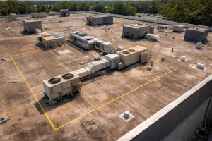
Rooftop Visual Documentation
Roof systems protect everything beneath them, yet they are often overlooked until a problem becomes obvious. Drone-based rooftop documentation offers a fast, safe way to visually document roof conditions without walking fragile surfaces or deploying access equipment.
Common rooftop documentation targets
- Surface damage, punctures, and membrane wear
- Loose or damaged flashing and edge details
- Standing water and drainage patterns
- Condition around penetrations and rooftop equipment
- Storm-related damage and debris
Aerial imagery allows facility managers to identify areas that warrant closer attention and prioritize maintenance before leaks or structural damage occur.
When rooftop drone documentation is most valuable
- Routine visual condition records
- Pre-purchase or pre-lease visual review support
- Post-storm documentation
- Before-and-after repair documentation
- Monitoring known problem areas
Telecom Documentation
Telecom infrastructure is critical and often elevated, making traditional visual review complex and weather-dependent. Drone inspection-support imagery provides clear visuals of antennas, mounts, cabling, and site layout without requiring climbing or specialized access in many cases.
Telecom assets commonly documented
- Antenna and mount condition (visual review)
- Cable routing and visible management issues
- General structural condition
- Rooftop or ground site context
- Storm impact documentation
These visuals support maintenance planning, contractor coordination, and stakeholder reporting, especially for teams managing multiple sites.
Long-term monitoring for telecom sites
Over time, small changes around a telecom site—vegetation growth, nearby construction, or gradual component wear—can impact access and performance. Periodic aerial documentation creates a reliable visual record that helps identify these changes early.
Utility Visual Documentation
Utility assets often span large areas and operate under strict safety and access requirements. While some utility review work requires specialized testing, drone imagery can provide valuable visual documentation to complement other professional methods.
Utility documentation use cases
- General condition documentation of structures and facilities
- Post-storm damage overview
- Vegetation encroachment context
- Access planning and site overview
- Visual review of hard-to-see areas
The goal is improved situational awareness, helping teams understand conditions before sending crews into the field or planning repairs.
Post-event documentation
After severe weather, drone inspection-support imagery can quickly capture a broad overview of affected areas. This helps prioritize response, document access challenges, and document conditions for internal reporting or insurance purposes.
Solar Visual Documentation
Solar installations represent a significant investment, and maintaining physical integrity is essential to long-term performance. While specialized sensors are required for detailed electrical analysis, standard aerial imagery still provides substantial value for visual documentation.
What aerial imagery can reveal on solar assets
- Visible panel damage or misalignment
- Racking and mounting condition
- Debris accumulation and soiling patterns
- Vegetation growth and shading risk
- Overall site layout and access conditions
For rooftop solar, visual documentation often overlaps with roof review, providing a broader picture of both the array and the supporting structure.
Ground-mounted solar fields
Drone imagery is particularly effective for large solar fields, where aerial coverage makes it easy to document alignment, drainage, access roads, and vegetation management needs across the entire site.
Deliverables That Support Real Work
Visual documentation is only useful if it’s organized and easy to interpret. Southview Drone Imaging focuses on delivering visuals that integrate smoothly into real-world workflows.
- High-resolution photos for detailed review
- 4K aerial video for broader context
- Time-stamped image sets for record-keeping
- Optional annotations to highlight areas of concern
- Before-and-after comparisons for verification
Clear organization
Images can be grouped by asset, elevation, date, or documentation area. For organizations managing multiple sites, consistent organization makes archiving and retrieval straightforward.
Using Aerial Documentation for Smarter Maintenance Planning
Aerial documentation supports a proactive maintenance strategy. Instead of reacting to failures, teams can plan repairs and replacements based on documented condition and visible trends.
Baseline documentation
Baseline documentation establishes a starting reference point. This is especially useful after acquisition, installation, or a major repair, providing a clear record of condition at a known point in time.
Routine monitoring
Periodic documentation helps identify gradual changes and support budgeting decisions. Even annual aerial checks can significantly improve visibility into asset health.
Post-event documentation
After storms or incidents, drone inspection-support imagery provides fast documentation that supports visual review, contractor coordination, and communication with stakeholders.
Safety and Professional Operation
All inspection flights are conducted in accordance with FAA Part 107 regulations and established safety practices. Proper planning ensures documentation flights are completed efficiently while respecting site conditions and operational constraints.
Working around active sites
Many documentation flights occur while assets remain in service. Flights are planned to minimize disruption, coordinate with on-site personnel, and maintain a focus on safe, professional operation.
Why Choose Southview Drone Imaging
Asset documentation requires more than aerial capability—it requires a disciplined approach to documentation. Southview Drone Imaging focuses on clarity, repeatability, and deliverables that help you make confident decisions.
Whether you manage rooftops, telecom infrastructure, utility assets, or solar installations, we tailor each documentation flight to your specific goals and operational needs.
Request Asset Documentation
If you’re ready to improve visibility into your assets, Southview Drone Imaging can help you plan a documentation workflow that fits your requirements, whether it’s a one-time visual record or an ongoing monitoring program.
The result is simple: safer visual review, better documentation, and clearer decisions backed by professional aerial imagery.
Next steps
Tell us what you need and we’ll recommend the best deliverables and turnaround.