Roof & Property Damage Documentation in Central Florida
Clear aerial documentation that captures damage safely, preserves visual records, and supports insurance claim discussions, repairs, and informed decision-making.
Quick Answer
Roof and property damage documentation captures dated aerial visuals of visible roof, exterior, and site conditions. It can support maintenance, contractor review, repair planning, and insurance claim discussions, but it does not replace a licensed roof inspection, engineering report, or insurance coverage decision.
When property damage occurs, clarity matters. Whether the cause is severe weather, aging materials, construction activity, or an unexpected incident, the ability to clearly document visible conditions can make repair planning and review discussions more organized. Unfortunately, damage is often located in areas that are difficult, unsafe, or impractical to inspect from the ground.
Roofs, building exteriors, and large properties present unique challenges after a loss event. Surfaces may be unstable, wet, or obstructed by debris. Access equipment can be expensive or slow to deploy, and conditions may change quickly as temporary repairs begin. Drone-based roof and property damage documentation provides a safer, faster way to capture clear visuals before conditions change.
At Southview Drone Imaging, we provide professional roof and property damage documentation services designed to support property owners, managers, contractors, insurers, and adjusters. Our focus is on clear, organized visuals that preserve the facts and reduce uncertainty when it matters most.
What Is Roof & Property Damage Documentation?
Roof and property damage documentation is the process of capturing visual records of damage to structures and surrounding property. This documentation is often used to support insurance-related discussions, guide repair planning, and create a clear record of conditions at a specific point in time.
Drone-based documentation focuses on areas that are difficult or unsafe to access, such as rooftops, elevated facades, large parcels, and wide site contexts. High-resolution aerial imagery provides both close-up detail and broad perspective, helping all parties understand the full scope of damage.
Why aerial documentation is critical
Damage rarely exists in isolation. A missing shingle may be part of a larger wind pattern, or a roof leak may relate to drainage issues across the entire structure. Aerial imagery captures context, showing how individual damage points relate to the whole property.
Just as important, aerial documentation preserves visual records before it is altered by repairs, weather, or cleanup efforts.
Common Causes of Roof & Property Damage
Property damage can occur for many reasons. Regardless of cause, timely documentation helps establish what happened and when.
Storm and weather events
Wind, hail, heavy rain, and hurricanes are among the most common causes of roof and exterior damage. Drone imagery can capture:
- Missing, lifted, or damaged roofing materials
- Impact marks from hail or debris
- Standing water and drainage issues
- Wind-related damage patterns across the roof
- Debris accumulation and displacement
Aging and wear-related damage
Over time, roofing systems and exterior materials degrade. Drone documentation helps identify visible wear, seam separation, surface deterioration, and other issues that may contribute to leaks or failure.
Construction or nearby activity
Construction work—on the property itself or nearby—can sometimes result in accidental damage. Aerial documentation helps capture roof and site condition before and after work occurs, supporting accountability and project review.
Impact and accidental damage
Falling debris, vehicle impacts, or equipment incidents can cause localized or widespread damage. Drone imagery provides a safe way to document these areas without exposing personnel to additional risk.
Why Use Drones for Damage Documentation?
Drone-based documentation offers practical advantages over traditional access methods, especially in post-damage scenarios.
Improved safety
After a loss event, surfaces may be unstable or slippery. Drones allow documentation to be captured without placing people on compromised roofs or near hazardous conditions.
Faster response
Time is critical when documenting damage. Drone flights can often be scheduled and completed quickly, capturing visual records while conditions are still unchanged.
Comprehensive coverage
Ground-level photos often focus on obvious damage but miss broader context. Aerial imagery captures the entire roof or property, helping ensure nothing is overlooked.
Clear, shareable visuals
High-resolution aerial images are easy to share with insurers, adjusters, contractors, and stakeholders, reducing misunderstandings and speeding up communication.
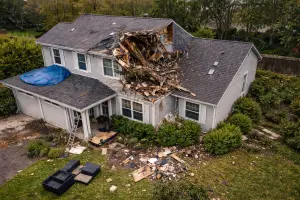
Roof Damage Documentation
Roof systems are one of the most critical and vulnerable parts of a structure. Damage is often difficult to see from the ground, yet even small issues can lead to serious interior problems.
What aerial roof documentation can reveal
- Missing, cracked, or displaced shingles or tiles
- Membrane punctures or surface damage
- Flashing and edge detail issues
- Ponding water and drainage paths
- Damage around penetrations and rooftop equipment
These visuals help determine the extent of damage and guide next steps, whether that involves temporary repairs, full replacement, or further inspection.
Residential and commercial roofs
Drone documentation is effective for both residential and commercial properties. Large commercial roofs, in particular, benefit from aerial coverage that shows damage patterns across the entire surface rather than isolated points.
Property & Site Damage Documentation
Damage is not always limited to the roof. Storms and incidents can affect siding, windows, fencing, landscaping, parking areas, and surrounding land.
Exterior building elements
Aerial imagery can document damage to:
- Facades and siding
- Gutters and downspouts
- Windows and exterior fixtures
- Balconies, awnings, and architectural features
Ground-level and site impacts
Drone imagery also captures broader site conditions, such as:
- Fallen trees or debris
- Flooding or erosion
- Damaged fencing or access points
- Impacts to parking areas and driveways
This context is often valuable for understanding the full scope of a loss event.
Supporting Insurance Claims
One of the most common uses of roof and property damage documentation is insurance support. Clear visuals help reduce uncertainty by providing an objective visual record of condition and change.
Establishing extent of damage
Aerial imagery helps demonstrate how widespread damage is, rather than relying on limited close-up photos. This broader view can be critical when evaluating claim scope.
Time-stamped visual records
Documented capture dates help establish when damage was observed. This can be important when claim discussions involve specific storm events or policy timeframes.
Reducing disputes
When all parties can see the same visuals, disagreements are less likely. Clear documentation keeps discussions focused on facts rather than assumptions.
Before-and-After Comparisons
Damage documentation becomes even more powerful when paired with prior imagery. Before-and-after comparisons clearly show what changed as a result of a loss event.
Baseline imagery
Baseline aerial documentation—captured before damage occurs—provides a reference point that supports future claim discussions and clarifies pre-existing visible conditions.
Post-repair documentation
After repairs are completed, aerial imagery can document completed work for qualified review and document restored condition for records and peace of mind.
Deliverables That Preserve the Facts
Damage documentation is only useful if it is organized and clear. Southview Drone Imaging focuses on delivering visuals that are easy to review.
- High-resolution aerial photographs
- Wide-area overview images
- Close-up detail shots from safe vantage points
- Time-stamped image sets
- Optional annotated images highlighting damage areas
Clear organization and labeling
Images can be grouped by date, location, roof section, or damage type, making review and sharing straightforward.
Safety, Compliance, and Professional Operation
All documentation flights are conducted in accordance with FAA Part 107 regulations and established safety practices. Operations are planned to minimize risk and avoid disruption to occupants and surrounding properties.
Operating around damaged properties
Flights are planned with extra care when structures may be compromised. Safety of people and property is always the top priority.
Why Choose Southview Drone Imaging
Roof and property damage documentation requires precision, neutrality, and professionalism. Southview Drone Imaging focuses on delivering clear, factual visuals that help all parties understand what happened—without exaggeration or omission.
We tailor each documentation project to the property, the type of damage, and the intended use of the imagery.
Creating Clarity When It Matters Most
Damage events are stressful, but documentation doesn’t have to be. Professional aerial imagery provides clarity, preserves visual records, and supports fair outcomes.
If you need roof or property damage documentation, whether for insurance, repairs, or records— Southview Drone Imaging is ready to help capture the facts safely and accurately.
Next steps
Tell us what you need and we’ll recommend the best deliverables and turnaround.