Before & After Property Documentation Packs in Central Florida
Clear, time-stamped aerial documentation that supports insurance claim discussions, reduces disputes, and provides confidence before and after loss events.
Quick Answer
Before-and-after property documentation creates organized visual records before and after storms, repairs, construction, or other site events. These image sets can support contractor review and insurance claim discussions, but they do not determine coverage, causation, or repair scope.
Insurance claim discussions often come down to one critical factor: visual records. When damage occurs, insurers, adjusters, and property owners all rely on documentation to understand what happened, what changed, and what condition the property was in before the event. Unfortunately, many claims become delayed or disputed simply because the available documentation is incomplete, unclear, or inconsistent.
Before/after property documentation packs solve that problem by creating a clear visual record of property condition over time. Drone-based aerial imagery captures comprehensive, high-resolution visuals that are time-stamped, repeatable, and easy to interpret. When combined into an organized documentation pack, these visuals provide powerful support for insurance claim discussions related to storms, accidents, construction impacts, or other loss events.
At Southview Drone Imaging, we create professional before/after property documentation packs designed to support property owners, facility managers, insurers, and adjusters. Our focus is on clarity, consistency, and documentation that stands up to scrutiny when it matters most.
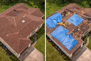
What Is a Before / After Insurance Documentation Pack?
A before/after property documentation pack is a structured set of visual documentation captured at two or more points in time. The “before” imagery establishes a baseline condition of the property, while the “after” imagery documents changes following a specific event.
These packs are commonly used to support claim discussions related to:
- Severe weather events (hurricanes, wind, hail, flooding)
- Storm-related roof or exterior damage
- Construction-related impacts or disputes
- Vehicle or equipment incidents
- Fire, debris, or site access damage
The strength of a documentation pack lies in consistency. When imagery is captured using similar perspectives, coverage areas, and flight plans, differences between “before” and “after” become clear and easy to demonstrate.
Why visual records matter
Written descriptions and ground-level photos can be subjective or incomplete. Aerial imagery provides context—showing not just isolated damage, but how that damage relates to the entire structure or site. This context is especially valuable when claim discussions are reviewed by parties who were not present before or after the event.
Clear visuals reduce ambiguity, limit interpretation errors, and help keep discussions focused on facts rather than assumptions.
Why Use Drones for Insurance Documentation?
Many insurance claim discussions involve damage to elevated or hard-to-reach areas such as rooftops, building facades, or large properties. Drone-based documentation offers advantages that traditional access methods often cannot match.
Safer data collection
After a loss event, conditions may be unstable. Roofs can be slick, structurally compromised, or littered with debris. Drone inspection-support imagery allows documentation to be captured without putting people at unnecessary risk.
Faster documentation
Time matters during insurance claim discussions. Drones can capture comprehensive coverage in a single visit, allowing documentation to be assembled quickly while conditions are still fresh and before temporary repairs alter the scene.
Complete coverage
Ground photos often focus on obvious damage, but miss broader context. Aerial imagery captures the entire roof, structure, or site, helping demonstrate the full extent of damage or confirm areas that were unaffected.
Repeatable viewpoints
Consistent aerial perspectives make comparisons straightforward. When before and after images are captured from similar angles and altitudes, differences are immediately visible and easier to explain.
The “Before” Component: Establishing Baseline Condition
The most effective property documentation packs begin long before any damage occurs. Baseline documentation establishes the condition of a property at a known point in time, creating a reference that can be invaluable later.
Why baseline documentation is important
Without “before” imagery, discussions often rely on assumptions about prior condition. Baseline aerial documentation removes that uncertainty by showing exactly what was present before the event.
Baseline imagery can help demonstrate:
- Roof condition prior to a storm
- Existing wear versus new damage
- Proper installation and maintenance
- Absence of pre-existing issues
When to capture baseline imagery
Baseline documentation is especially valuable when captured:
- At regular intervals (annual or semi-annual)
- Before storm seasons
- After major repairs or replacements
- During property acquisition or handover
Even a single baseline documentation flight can strengthen future claim discussions by providing a clear point of comparison.
The “After” Component: Documenting Change
After a loss event, accurate documentation becomes urgent. Drone-based inspection-support imagery can capture damage quickly, safely, and with minimal disruption—often before temporary repairs begin.
Post-storm and post-event documentation
Following severe weather or incidents, aerial imagery can document:
- Missing or damaged roofing materials
- Impact marks, punctures, or debris
- Water intrusion indicators and ponding
- Structural damage or displacement
- Surrounding site conditions and debris fields
Capturing this information early helps preserve visual records and provides a clearer picture before conditions change.
Supporting repair planning
After imagery doesn’t just support claim discussions—it also helps contractors and facility managers plan repairs. Clear visuals make it easier to scope work, estimate materials, and prioritize urgent issues.
Organized Documentation Packs That Make Sense
A property documentation pack is only effective if it’s organized and easy to interpret. Southview Drone Imaging focuses on delivering documentation that tells a clear story.
Documentation packs may include:
- High-resolution “before” aerial images
- High-resolution “after” aerial images
- Time-stamped files showing capture dates
- Consistent viewpoints for comparison
- Optional annotated images highlighting changes
Clear labeling and structure
Files can be organized by date, elevation, roof section, or asset area. Clear naming conventions help adjusters, insurers, and contractors quickly understand what they’re reviewing—without digging through disorganized folders.
Who Uses Before / After Documentation Packs?
Insurance documentation packs are useful for a wide range of stakeholders involved in property ownership, risk management, and property records.
Property owners and managers
Owners and managers use documentation packs to support claim discussions, reduce uncertainty, and maintain accurate records of property condition over time.
Insurance adjusters and carriers
Clear aerial documentation helps adjusters assess damage more efficiently and make informed determinations without relying solely on descriptions or limited ground photos.
Contractors and restoration teams
Before/after visuals help contractors understand scope, verify completed work, and document results, especially when coordinating with insurers or third parties.
Commercial and multi-site organizations
Organizations managing multiple properties benefit from standardized documentation packs that create consistency across sites and claim discussions.
Reducing Disputes and Delays
Many insurance disputes stem from uncertainty about pre-existing conditions or the extent of damage. Before/after documentation packs help reduce these issues by presenting clear, side-by-side documentation.
When all parties can see the same visuals, conversations become more productive and less adversarial. This often leads to faster resolutions and fewer delays.
Supporting fair outcomes
The goal of a documentation pack isn’t to exaggerate damage—it’s to document reality. Clear, organized visuals support fair assessments based on facts rather than assumptions.
Safety and Professional Operation
All documentation flights are conducted in accordance with FAA Part 107 regulations and established safety practices. Proper planning ensures safe operation around buildings, people, and active sites.
Working around damaged or active properties
After an event, properties may still be occupied or undergoing temporary stabilization. Flights are planned to minimize disruption and prioritize safety while capturing the required documentation.
Why Choose Southview Drone Imaging
Insurance documentation requires accuracy, consistency, and professionalism. Southview Drone Imaging focuses on delivering documentation packs that are clear, organized, and defensible. We understand that these visuals may be reviewed by multiple parties and must stand on their own.
Our approach emphasizes repeatable capture, clear organization, and deliverables that support real-world insurance workflows.
Prepare Before the Next Event
The best time to think about insurance documentation is before you need it. Establishing baseline aerial imagery now can save time, reduce uncertainty, and support future claim discussions.
If you’d like to create a before/after property documentation pack, or set up a simple baseline documentation plan—Southview Drone Imaging is ready to help.
Next steps
Tell us what you need and we’ll recommend the best deliverables and turnaround.